Sunday 14/6/26 - Gloucester Urban Race (UKUL and NGOC League 6)
Gloucester is an historic cathedral city and the county town of Gloucestershire. Located on the River Severn, it is the most inland port in Britain. For the orienteer, it offers much variety: the city centre, the cathedral and its close, Victorian docks, the canal and river, intricate housing areas and semi-rural Alney Island.
This is the first time in 10 years that we are back in Gloucester. In the interim, there has been plenty of changes, so the map has been much refreshed and extended.
We are grateful to: Gloucester City Council and the Canal and River Trust for their permissions and to Llanthony Secunda Priory for hosting us in their picturesque grounds and mediaeval buildings.
There will be 7 courses exploring the city - see the note about under 16s, but otherwise these are open to all, whether you’re new to orienteering or a seasoned veteran. There is even an 'accessible' course suitable for wheelchair users.
Entries are open on Fabian 4, and will close at midnight on Thursday 11th June.
Why not make a weekend of it... Our neighbours Harlequins Orienteering Club are hosting a Regional Urban event in Worcester the day before.
Officials
- Organiser/Planner: Greg Best, NGOC
- Controller: Adrian Bailey, HOC
Queries? communications@ngoc.org.uk
Directions and Parking
Assembly is at Llanthony Secunda Priory, Gloucester, GL2 5FZ
Start and Finish will be adjacent to assembly. Start times will not be assigned: just come to the start when you're ready.
By car: The closest and easiest place to park is at Gloucestershire College (///paying.parts.yarn) with a short walk to assembly of about 200m which will be taped from the footpath exit at the west end of the car park. Fees on a sunday are £1/hour or £3 all day. Note that this car park is accessed from Llanthony Road, which can only be approached from the A430. Do not approach over Llanthony Bridge from the east, as cars are no longer permitted to cross this and would result in a definite fine in the post! In the unlikely case that this is full, the next best place to park is Castlemeads Car Park (///richer.saints.tonic) with a walk to assembly of about 400m. Fees on a sunday are £2.30 all day. This car park is also approached from the A430.
By public transport: Gloucester railway station and bus station are both within easy walking distance, about a mile away.
Click on the parking icon on the map below, and then the
icon to get directions to the course.
"
The Area
Gloucester is mostly pretty flat - the main exception will be steps and bridges. Most of the area is paved, although there are some small grassy areas. The longest courses will also visit Alney Island where there are fields and woods to be crossed. The island is prone to flooding, particularly in the winter time. We hope it will be nice and dry in June! Shorts, vests and normal trainers should be fine.
Expect to encounter a mix of historic city centre, newer housing developments, waterways, plus semi-rural on the island. There are some multi-level sections, so make sure you read the mapping notes if not used to how this is represented.
Sadly, permission was denied to us for use of a large chunk of the docks, so courses have had to be redesigned accordingly.
Other Important Notes
Course 1 (Brown) has a lot of controls, so older dibbers are not suitable for running this course. You will need a series 9 or later to have sufficient capacity. NGOC hire dibbers are not suitable unless it's one of the SIAC ones.
All courses will have one time-out section in order to cross one of two different bridges that are occasionally swung or lifted open to allow boats to pass through. The time-outs are of an unlimited duration, so if you are unlucky to get caught out, don't panic, just wait however minutes necessary for the boat to pass through. You must punch both controls either side of the bridge in the normal manner.
The junior courses (Yellow and Orange) have a taped route between 2 controls. You MUST stick to the edge of the road next to the tapes and not be tempted to cross the road.
The Map
ISSprOM map at the scale of 1:4000 with 2.5m contours, significantly updated/extended/redrawn by Greg Best. Note that north is not at the top of the page! The map has been rotated by 23 degrees in order to fit on the area we wished to use. Hence, grid lines are at an angle to the page.
Control descriptions will be printed on the map and available loose in the start lanes.
Here, you can view the symbols used by the ISSprOM (urban mapping spec)
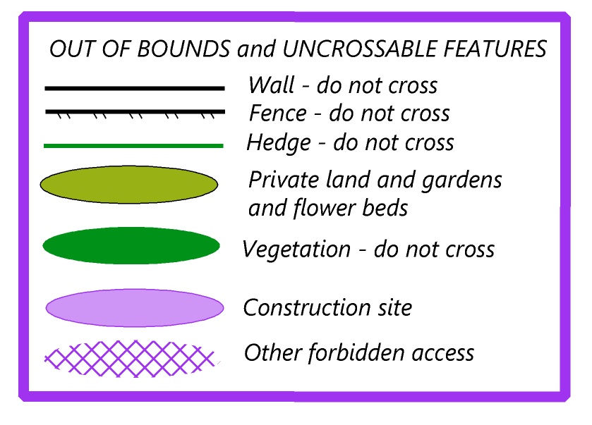
Important. The following symbols indicate restrictions on access. You must obey all such symbols shown on the map. You will be disqualified if seen or reported crossing any of these.
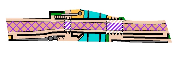
There are a number of structures which allow passage at 2 levels. It is important to understand how these are depicted. One particular bridge shown below will also be crossed by the junior courses, so please explain this to any children running these courses. Juniors will cross this bridge both underneath and over the top. The striped areas depict places that can be run at 2 levels. The black "shark teeth" indicate where there is an uncrossable barrier on the top level but below there is an entrance through. The hatched out road on the top level is out of bounds, but the pavement alongside it is not.

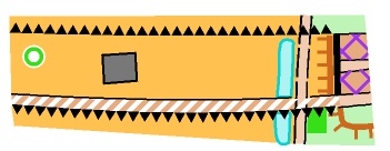
There are a number of bridges that are shown as "ghost bridges", such as the one below. These bridges are only indicated by the black "shark teeth". This allows the detail to be shown underneath, as (most of) the upper level is for cars only, so not relevant to the orienteer. Note that there is sometimes a pavement shown above that can be used (as in this example) - but at the upper level only.

There are some gates on Alney Island that are locked and will need to be climbed, while others do not, as shown in the example below. The one on the left has a fence line through the crossing point indicating it needs to be climbed, whereas the one on the right is passable more easily.

Courses
| Course | UKUL categories | Optimum Length | #Controls | Map size | NGOC League | Suitable for |
|---|---|---|---|---|---|---|
| 1 | MO (18-35) WO (18-35) MV (40+) | 12km | tbc | double-sided A3 | Brown | Anyone (aged 16+) |
| 2 | WV (40+) MSV (55+) | 9km | tbc | double-sided A3 | Blue | Anyone (aged 16+) |
| 3 | WSV (55+) MUV(65+) | 8km | tbc | A3 | Green | Anyone (aged 16+) |
| 4 | WHV WUV (65+) MHV (75+) | 5.5km | tbc | A3 | Short Green | Anyone (aged 16+) |
| 5 | MJ WJ (16-) | 5km | tbc | A4 | Orange | Older and Improving children |
| 6 | MYJ WYJ (12-) | 3km | tbc | A4 | Yellow | Children |
| 7 | Accessible (not UKUL) | 2.5km | tbc | A4 | n/a | Wheelchair users |
Climb is negligible on all courses so will not be shown on control descriptions
There will not be a STRING course. There will also not be a RED course, as all course are suitable for novices at this event.
You MUST go to Download even if you do not complete your course – we need to confirm that you are back safely!
Split starts. In order to minimise demands on scarce volunteer resources we operate a 90 minute start window for this event, and we recognise that this can be a challenge for parents seeking split starts. We are happy to accommodate split starts provided:
- You let us know in advance that you need a split start. Do this by emailing the organiser, address in the introduction above
- You come early; the start team will normally be ready to allow very early starts up to 30 minutes before the published start time, so aim to be there with this in mind. We do not offer starts later than the published end of the start window.
- The shorter course runner goes first. We will not turn you away if you can't manage this, but it gives you both a better chance of beating the course closure time.
Entries, Timing and Fees
Entry Details
Starts: 11:00 - 12:30.
Courses close: 14:00, meaning that you must report to download before 14:15, or risk disqualification.
| Fees | Pre-entry | Entry on the Day | Non-member Supplement |
|---|---|---|---|
| Adults | £8 | £10 | £2 |
| Juniors | £3 | £4 | £1 |
| Family (2 adults + their children) | £16 | £20 | As above for any non-members |
SI dibber hire: Standard dibber £1 Adults, Juniors free
Touch Free dibber: £2 Adults, £1 Juniors
Entries are now open, and will close at midnight on Thursday 11th June.
Entry on the day is possible only while maps last, but note the premium price to discourage this. We should be able to accept credit/debit card payments, but this is not guaranteed so bring cash just in case.
Please note that we keep entries open as late as we can subject to map printing. If you miss the deadline you are welcome to enter on the day, and there will invariably be a map available for the course you choose to run. We will not reserve maps for people who contact us after entries close and ask us to do so; you take your chance with all others who choose to enter on the day.
A helper discount is available for those offering to help on the day. These events don't happen without volunteers willing to help out on the day, so if you are able to do so, before signing up to enter, email Ian Prowse, Volunteer Coordinator, to let us know if you can help, and ask for the helper discount code that you can apply when entering. You don't have to be a NGOC member to help, but you do need to be a BOF member to be covered insurance wise.
Facilities
There are toilets at the Llanthony Secunda Priory where we are based.
The NGOC cafe will be present there too. There is also a wide range of refreshment places around the nearby historic docks.
The priory's Information Room is adjacent to where our cafe and download will be situated, so worth taking a look. They also holding an
Open Day on the day of the event which you may be interested in too.
Safety
- Courses 1-4 will encounter roads and car parks, some of which will be busy. Certain road sections are marked out-of-bounds: do not cross the road in these areas except via the marked bridges, subways and crossings. Note: runners under the age of 16 on the day of the event are not permitted to run courses 1-4 unaccompanied.
- Course 5 will encounter a housing estate with some 20mph dead-end roads. Take care and look before crossing these.
- All courses will encounter members of the public, dog walkers etc. Please be courteous to all you meet and be prepared to give way.
- There is water in the canal, docks and river. This is often unfenced, so take care and do not go too close to the edge.
