Sunday 07/12/2025 – 2025 League 11 – Parkend Walk

Sunday 07/12/2025 – 2025 League 11 – Parkend Walk
Print this page

Sunday 07/12/2025 - 2025 League 11 - Parkend Walk

The penultimate race in the NGOC 2025 League will take place on Parkend Walk, including a new extension into Noxon Park, which brings the village of Bream into play for the longest courses getting over to the far Eastern areas of the map. This hasn't been used much for some time, but the going has improved and it has been fully remapped for this latest version of the Parkend map. Please note that to take advantage of this extension course lengths are right at or just over the top end of the guidelines for long distance courses. Please ensure that you check the course details, select a course appropriate to your abilities, and allow yourself sufficient time to complete your course before it closes. Bear in mind also that there is a 4-500m walk to download from the finish.

There will be an opportunity to do some training alongside/before the event. This will be in the form of a couple of exercises in an area close to Assembly which isn't used by the League courses. You are welcome to go to the training start area and collect an A5 map to do the exercises and we ask you that you please return the map to the box after you finish. There should be helpers on hand to assist you if needed.

Regrettably, though, there is nowhere suitable for a string course, as space we might have used near the clubhouse needs to kept clear for people attending the youth football match in the afternoon.

We would like to thank Forestry England for permission to run in this area.

Entries are now open at Fabian 4, and will close at midnight on Thursday 4th December.

     Enter Online

Officials

Organiser and Planner: Gary Wakerley NGOC For any pre-event questions, please email Gary

Biosecurity

Basic biosecurity controls must apply to this event given current plant health disease containment issues. In practice this means attendees must arrive with clean footwear and clean off mud and debris before leaving the area.

We should all be checking our clothing and equipment before leaving the car park to ensure that there is no visible plant material either on our shoes or our clothing. If there is any plant material it should be removed and left on site. We should also knock off any soil or leaf litter.

Once home, please thoroughly clean your footwear and clothing and then leave it to dry for as long as possible. Many of the INNS (Invasive Non-Native Species) are able to survive in damp corners for very long periods of time but are less able to survive if equipment is thoroughly dried.

CHECK – CLEAN – DRY.

Directions and Parking

Parking is in the car park adjacent to Ellwood Primary School, which is on the road as you approach the area. Overflow parking if needed will be along the road beyond the school, and in the area around the football pitch. Only helpers will be parked at the football club, in order to leave space there for an afternoon youth team football match.

W3W: ///toothpick.goats.lift.

Grid Reference: SO593081

Registration and download are at Ellwood Football club, which will be open for drinks and snacks during the day.

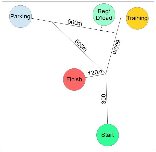
The diagram below shows walking distances between the various event locations. Please note also that the start window is 30 minutes earlier than of late, so plan your visit with this in mind, and allow plenty of time to get to the Start.
Event map

Public transport is non-existent but we strongly encourage participants to car share where possible. NGOC runs a Car Sharing WhatsApp group called NGOC Ride Share for those who need or can offer a lift. Request an invitation to join by emailing equipment@ngoc.org.uk, or texting Pat Macleod, if you have his mobile number.

Click on the parking icon on the map below, and then the Direction icon icon to get directions to the course.

The Area

The updated Parkend map now consists of 4 principal areas. The core of the previous map is a large area of mainly coniferous forest, much of which is covered with thick brambles, and largely avoided by all courses. There are some nice areas of deciduous woodland however, some of these pockmarked with many platforms and depressions, a legacy of very small scale drift coal mining and charcoal burning. The Eastern part of the map, adjacent to Whitemead Park holiday resort is a patchwork of mainly coniferous forest of variable runnability, and is visited only by the Brown course. The newer extensions to the map include much of Bream village, and Noxon Park, visited by Brown, Blue and Green courses, where there is extensive old mine working. This is fenced and mapped as Out of Bounds and may not be entered, although there is no reason to do so.

The principal road between Bream and Sling is fairly quiet, and straight, so visibility at marked crossing points is reasonably good, but traffic may be fairly fast moving. It is marked as Out of Bounds where there is no pavement, and may not be run along where shown as Out of Bounds. It may however be crossed at various points, which are mapped with the optional crossing point symbol, meaning that any may be used. In Bream itself, and relevant only to the Brown course, most roads have pavements and may be run along. Runners under 16 may not run the Brown course, but are permitted on all others.

Traffic in Bream itself is generally slow moving due to many parked cars on all roads, but runners on Brown should take care when crossing the village roads.

The Map

Maps are pre-printed on waterproof paper. Brown, Blue, and Green courses have A3 size maps at 1:10,000 scale, 5m contours. All other courses have A4 size maps at 1:7,500 scale, also with 5m contours.

Areas with heavy brashings that may slow progress have been mapped with the undergrowth slow run symbol (widely spaced vertical green lines). Generally routes can be found around the brashings. Bracken is widespread but seasonal dieback is now well advanced. The mapping philosophy for winter races is to map bracken which is fairly dense and still standing with the wide space screen, and bracken which also hides brambles with the narrow spaced vegetation screen. Areas where the bracken is sparse and generally easy to run through are mapped as white forest.

Start and Finish

The start is located 600m from the registration and download at the football club. See the diagram in the Parking section. Latecomers who may be parked in the overflow area, and who do not need to go to Registration, can take an alternative route to the start, slightly shorter at 900m, than going via Registration. The finish is 120m from the point where start routes from Registration and Overflow parking meet. You cross a pasture field in which there may be sheep. Make sure you close the exit gate.

SI Touch free punching is enabled, but all runners must punch both Start and Finish.

Courses

Standard NGOC League courses are available: Brown, Blue, Green, Short Green, Orange and Yellow. Regrettably there is no suitable location for a string course, given the distributed nature of the event locations. As stated above, course lengths are at the very top end of the guidelines, and in planning your visit you should allow for this, and for the time required to get to the start, and back from the finish.

Regrettably there will not be a string course available, as there is no suitable location for one, once our training activity is taken into account, together with the need to keep space available for parking for people attending the youth football team game after lunch on event day.

Remember that you can do some informal training before or after your run if you fancy it. There will be a couple of exercises in an area close to Assembly which isn't used by the League courses. You are welcome to go to the training start area and collect an A5 map to do the exercises and we ask you that you please return the map to the box after you finish. There should be helpers on hand to assist you if needed.

Class/Course length(Km) Climb(m) Controls Map Suitable for
Brown 8.6 410 16 A3, 1:10,000 Experienced Orienteers
Blue 5.5 265 12 A3, 1:10,000 Experienced Orienteers
Green 4.1 185 9 A3, 1:10,000 Experienced Orienteers
Short Green 3.5 135 8 A4, 1:7,500 Experienced Orienteers
Orange 3.3 125 8 A4, 1:7,500 Adult beginners and improving children
Yellow 2.8 90 11 A4, 1:7,500 Children

Course details subject to final controlling. Course distances are straight line.

We will use SI Timing, in contact and touch free modes. All runners must however punch the Start and Finish controls.

You MUST go to Download even if you do not complete your course – we need to confirm that you are back safely!

Whistles must be carried by juniors running on their own and are highly recommended for all competitors. If you hear a distress whistle, please go to assist.

In order to minimise demands on scarce volunteer resources we operate a 90 minute start window for this event, and we recognise that this can be a challenge for parents seeking split starts. We are happy to accommodate split starts provided:

  • You let us know in advance that you need a split start. Do this by emailing the organiser, address in the introduction above
  • You come early; the start team will normally be ready to allow very early starts up to 30 minutes before the published start time, so aim to be there with this in mind. We do not offer starts later than the published end of the start window.
  • The shorter course runner goes first. We will not turn you away if you can't manage this, but it gives you both a better chance of beating the course closure time.

Entries, Timing and Fees

Entry Details

You should enter the course appropriate to your involvement in the NGOC league, if relevant, or whichever course you choose otherwise.

Starts: 10:30 - 12:00
Courses close: 13:30, meaning that you must report to download before 13:45, or risk disqualification.

Fees Pre-entry Entry on the Day Non-member Supplement
Adults £8 £10 £2
Juniors £3 £4 £1
Family (2 adults + their children) £16 £20 As above for any non-members

SI dibber hire: Standard dibber £1 Adults, Juniors free

Touch Free dibber: £2 Adults, £1 Juniors

Entries are open, and will close at midnight on Thursday 4th December.


Enter Online

Entry on the day is possible only while maps last, but note the premium price to discourage this. We should be able to accept credit/debit card payments, but this is not guaranteed so bring cash just in case.

A helper discount is available for those offering to help on the day. These events don't happen without volunteers willing to help out on the day, so if you are able to do so, before signing up to enter, email Ian Prowse, Volunteer Coordinator, to let us know if you can help, and ask for the helper discount code that you can apply when entering. You don't have to be a NGOC member to help, but you do need to be a BOF member to be covered insurance wise.

Refunds

The standard Fabian4 terms and conditions offer an automatic refund up to 2 months before the event date, and we do not normally vary this specification. That means that in most cases no refunds are possible, as we do not publish details until less than 2 months before the date of the event.

However, for all except large events we hold entries open until only a day or so before the event, so you can delay entry if unsure whether you can run, until very close to event day.

Dogs

Dogs are permitted on leads in the car park and assembly areas and under close control on the courses. Note that there may be livestock in a field that has to be crossed en route back from the finish

Facilities

First Aid will be available at assembly.

The Football club will be open for toilets, changing, and pre- and post run tea, coffee and snacks. You can deposit cash, cards and phones at Registration for safekeeping if you are parked remotely.
Please note that studded shoes may not be worn in the clubhouse, but may be left at the door.

If you are interested in obtaining club kit, whilst there will not be an extensive range of sizes to try on at the event, we can have a few sizes available for specific items. You can see the options, and a size chart, on the Club Kit page. Email paul@ngoc.org.uk with details of any items, and relevant sizes, you wish to try, and we can have those available.

Safety

Orienteering is an adventure sport. All runners take part at their own risk and must take responsibility for their own safety.

In the event of wet weather, please assess risks on any steep slopes.

Everyone is advised to carry a whistle, and for Juniors it is compulsory. Full leg cover is compulsory for everyone. In the event of severe weather, a cagoule may be made compulsory; please ensure that you bring one just in case.

A first aid kit and trained first aiders will be present at Registration. Note that we are not permitted to provide epi-pens or antihistamine tablets in the event of stings. If you know you react badly to stings you should carry your own epi-pen or antihistamine tablets.

There are several public roads in the event area, crossed only by Brown, Blue and Green courses. The latter two classes cross and recross only one relatively quiet road, at marked crossing points where visibility is reasonably good. The Brown course includes route choices through Bream village. All permissible roads have pavements, and traffic flow tends to be slowed significantly by numerous parked cars, but care must be taken when crossing these residential roads.

Parents/Guardians of Yellow course runners are advised that early in the Yellow course it runs first along a 70m stretch of tarmac road giving access to a single house (whose occupants are aware of the event and have been spoken to), and thence along a 150m further stetch of road giving access to only two houses. On a later part of the course it crosses a similar very minor road which gives access to a hamlet of about 12 houses. There is clear visibility either side of the crossing, and traffic is both both very rare and slow moving. Runners must be advised to take particular care on these legs.

Safety bearing. If lost the best option is to head North West and seek out the settlements of Little Drybrook, adjacent to the start, or Ellwood.

There are steep slopes and old quarry workings and great care should be taken when descending slopes especially in wet conditions.

All log stacks must be avoided.

The area is very popular with mountain bikers, whose tracks criss-cross much of the central part of the map. take special care if running downhill on anything that seems like a cycle track, where riders will be approaching from behind. Beware also bikers crossing the larger tracks and footpaths at speed

Orienteering is a great sport for young people. If you bring children, please help us to keep to our safeguarding policy and British Orienteering’s photography policy.

By entering this event, competitors agree to abide by the British Orienteering Code of Conduct.

A comprehensive risk assessment will have been carried out by the organiser and a copy will be held at Registration, but participants take part at their own risk and are responsible for their own safety during the event. All participants must report to download whether they finish their course or not.

When participating in our events/activities your name may appear in the results section of this website or in newspaper reports. To see how we look after your personal data, please read our privacy policy.

NGOC follows British Orienteering’s national guidance. This provides a sensible balance between the benefits and risks associated with the taking and use of images. If you are unsure about acceptable practice, please speak to the event organiser.